As part of the Sherwood Forest Archaeology Project, a computerised map of Sherwood Forest in medieval times is being produced. The map is based in Geographic Information Systems and is based on historic mapping research, LiDAR data, historical documentary research, secondary published sources, alongside the results of excavation, fieldwalking, survey and more from the Sherwood Forest Archaeology Project, and previous published work.
The output from the map will be in a number of formats including web-
The map primarily focuses on developing a high medieval landscape, located temporally in the 13th-
The map will be an interactive digital map, which is designed to enable further research, particularly with regard to locating the previous earlier medieval landscape of wood-
Although there have been previous attempts at mapping the forest area (unsuccessful) this map has been constructed from scratch via research at the archives and online, alongside extensive fieldwork.
This is the first such attempt to map the forest as a digital database, embedded not only with historical information regarding fields, woodland, heathland, villages etc, but also records and entries such as extracts from the Sherwood Forest books, Nottingham Borough records and more.
Construction of this map in Geographic Information Systems was begun from scratch in 2013 by Andy Gaunt, Director of Mercian Archaeological Services CIC. Elements of this map has been developed in consultation with Alan McCormack, former Keeper of Antiquities at Nottingham Castle; since 2013.
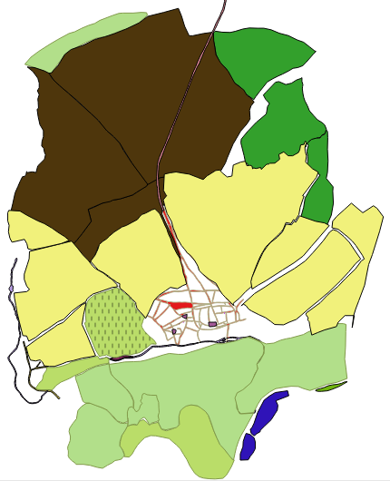
Picture: Medieval Nottingham. Extract from the data-
©Mercian Archaeological Services CIC 2018.
The map will be fully zoomable down to street level (see below) and elements such as extracts from the Nottingham Borough Records will be available to read.
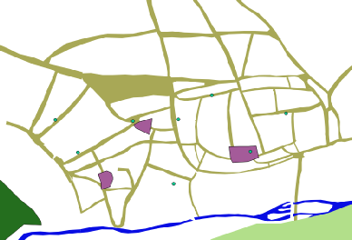
Picture: Medieval streets of Nottingham-
©Mercian Archaeological Services CIC 2018.
The mapping of area such as Clipstone, are based on previous work by Andy Gaunt into the designed landscape which he identified in 2011.
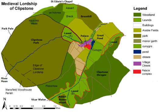
Picture: Gaunt 2011 map redrawn by Gaunt for 2013 publication in Thoroton Society Transactions (Gaunt & Wright 2013) with extra annotation and Launds higlighted.
©Mercian Archaeological Services CIC 2018.
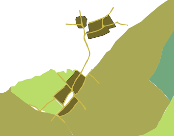
Picture; The medieval village cores of Church Warsop (North) and Market Warsop (South) showing the double core settlement plan. Extract from the data-
©Mercian Archaeological Services CIC 2018.
Project page links:
-
-
-
-
-
-
-
-
The Sherwood Forest
National Nature Reserve Archaeology Survey
-
Long term Research at
King John’s Palace:
Ancient Royal Heart of Sherwood Forest
-
The Sherwood Forest Archaeology Training Fieldschool
-
“Scirwuda-
Ghost and Shadow woods of Sherwood Forest Project
-
Investigating Thynghowe Viking
Meeting Site
-
Searching for the
The Battle of Hatfield
-
-
Fieldswork at St Edwin’s Chapel
-
St Mary’s Norton-
-
Mapping Medieval Sherwood Forest
-
The Sherwood Forest LiDAR
Project
-
Warsop Old Hall
Archaeological Project
-
The Sherwood Villages Project:
Settlement Development in the Forest
-
-
-
Researching Edward IIs fortification at Clipstone Peel
-
-
-
-
The Cistercians of Rufford Project:
Settlement Development, Dynamics and Desertion.
-
Sherwood Forest Environmental Survey
-
World War II in Sherwood Forest -
-
World War I in Sherwood Forest -
-
About Medieval Sherwood Forest
-
Robin Hood and Sherwood Forest
-
-
-
-
-
-
-
-
-
-
-
-
Community Archaeology in Derbyshire
Community Archaeology in Leicestershire
Community Archaeology Nottinghamshire, Excavation, Research, Volunteering, Community Archaeology Derbyshire, Training, Social, Learning, Community Archaeology Leicestershire, Heritage, Involvement, Belonging, Knowledge sharing, Community Archaeology Lincolnshire, Topographic Survey, Talks and Presentations, Outreach, Archaeology Projects , Open Days, Schools, Finds Processing, Day Schools, Field Schools, Young People, Archaeology and History of Sherwood Forest, Pottery Research, Medieval, Roman, Prehistoric, Community Interest Company, Community Archaeology Nottinghamshire.
Community Archaeology in Nottinghamshire
Community Archaeology East Midlands
Community Archaeology in Lincolnshire
Community Archaeology in Yorkshire
Mercian Archaeological Services CIC
Specialists in Community Archaeology, Public Involvement, Research & Training
© Mercian Archaeological Services CIC 2024. Registered Business No. 08347842. All Rights Reserved.


The Future of Sherwood’s Past


Community Archaeology Nottinghamshire, Community Archaeology Derbyshire, Community Archaeology Leicestershire, Community Archaeology East Midlands, Mercian Archaeological Services Community Archaeology for Nottinghamshire, Derbyshire, Sherwood Forest, Leicestershire and the East Midlands. Community Archaeology Nottinghamshire, Community Archaeology East Midlands, Community Archaeology Leicestershire. Archaeological
Sherwood Forest Interactive GIS mapping -