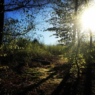
 Mercian Archaeological Services CIC are proud to be involved in investigating the Viking meeting site of Thynghowe in Sherwood Forest as part of the Sherwood Forest Archaeology Project for our partners the Friends of Thynghowe (FOT) and the Forestry Commission of England.
Fieldwork undertaken by Mercian includes 2 Heritage Lottery Funded Projects, which enabled archaeological excavations, environmental sampling, thermoluminesence dating, test-
Mercian have also undertaken geophysical magnetic survey and resistance survey of the site.
The Friends of Thynghowe have also undertaken LiDAR survey, ground-
Mercian are committed to the vision of the FOT and are dedicated to helping to ensure the site of Thynghowe in Sherwood Forest is investigated to the highest standards, and that the results are published academically to enable this site to be recognised internationally for its importance as part of the wider Viking Diaspora, and as one of the Thing sites of Europe.
Use the links below to navigate or scroll down view the page
[Intro] [The Friends of Thynghowe] [the Archaeology of Thynghowe] [Funding] [Archaeology projects] [Academic Output] [Links]
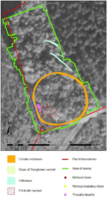
Picture from Gaunt 2017: The monument complex at Thynghowe, Sherwood Forest. Contains OS data © Crown copyright [and database right] 2017. Contains Image © Google Earth. Image © 2017 Getmapping plc.
The site of Thynghowe is located at the summit of Hanger Hill on the boundary of Budby, Warsop and Edwinstowe parishes, on the edge of Birklands wood, the home of the world famous Major Oak and the Sherwood Forest National Nature Reserve.
The name Thynghowe means ‘hill of assembly’ and the site is the location of a Viking Assembly site or ‘Thing’.
The site is home to a complex of monuments which has been slowly pieced together over many years through painstaking research by Mercian Archaeological Services CIC and the Friends of Thynghowe group.
This work includes:
- Archaeological excavations by Mercian in 2013 (Gaunt & Crossley 2014) and 2016 (Gaunt & Budge 2016 and Gaunt, Crossley and Budge 2017 forthcoming).
- Geophysical Magnetometer Survey by Mercian Archaeological Services CIC (Gaunt 2017)
- Magnetometer survey of the top of the mound by UCL (Brookes & Baker 2012)
- Map regression
- Topographic Survey, Landscape analysis and Level-
one survey (Gaunt 2011) - LiDAR Survey 2012
- Ground-
truthing survey by the Friends of Thynghowe (2012- present - The recent archaeological excavations by Mercian Archaeological Services CIC have also used scientific analysis of pollen, soil geomorphology, and thermoluminesence dating to help to answer the questions raised by work at the site.
The Friends of Thynghowe Group
Despite being told by the County Archaeologist for Nottinghamshire in 2004 that there was nothing at the site, Stuart Reddish and Lynda Mallett stuck to the task, formed the Friends of Thynghowe Group, and working alongside archaeological and other experts have helped to save, interpret and begin to understand and promote this amazing site at the heart of Sherwood Forest.
The group has spent 13 years so far studying, working, clearing, maintaining, promoting, and helping to protect this site.
They are an amazing example of what community action, commitment, and personal drive can achieve.
See the video at the bottom of this page and hear Lynda Mallet talk about the amazing story of how chance, or fate drove her and husband Stuart Reddish to purchase an historic document in Wales which led to them rediscovering the site and all the work that has happened since.
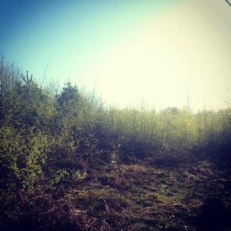
Photograph: The summit of Thynghowe © Mercian Archaeological Services CIC
Photo: Viking farmers return to Thynghowe in 2016 ©Lynda Mallett 2016
It simply cannot be stressed enough that without the dedication, knowledge, inspiration and continuous hard work of the Friends of Thynghowe (in particular Stuart Reddish, Lynda Mallett, Steve Horne, Sue and Bob Longden and all of the other volunteers at the site from the group and general public who have given their time) alongside the incredible efforts of staff in the Forestry Commission, (notably Amy Chandler, Tim Yarnell, and previously Andy Norman) the site of Thynghowe and its hugely important archaeological remains could have been lost forever and have remained unknown and unrecorded.
At the very least the reward for their collective efforts is that the site is beginning to be recorded and understood, and has been saved for future generations.
Visit their website at: http://www.thynghowe.org.uk/FoT.html to find out more about their work
Recent work at the site has helped to show that the site of Thynghowe consists of a complex of monuments including:
A ‘thing mound’,
A circular enclosure 75.0m -
Holloways including ‘Nether Warsop Gate’
A spread of pot-
Two possible hearths,
Boundary stones for Warsop and Edwinstowe,
The ‘Birklands Forest Stone’,
The ditch and bank of the boundary of Warsop and Edwinstowe Parish,
The possible identification as the village of Budby as meaning the ‘booth farm’ where delegates attending the assembly may have stayed in ‘booths’.
And possibly more features as yet unidentified.
This monument complex of possible ‘assembly features’ could be unique in terms of preservation anywhere in England, and possibly anywhere in Northern Europe and around the Viking Diaspora!
Thynghowe is certainly an important site for local heritage and the history of Sherwood Forest.
It may well be of international significance!
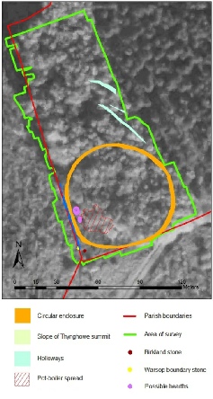
Picture from Gaunt 2017: The monument complex at Thynghowe, Sherwood Forest. ©Mercian Archaeological Services CIC .Contains OS data © Crown copyright [and database right] 2017. Contains Image © Google Earth. Image © 2017 Getmapping plc.
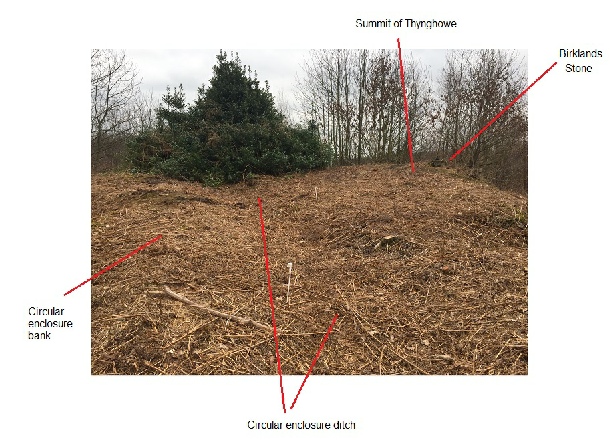
Photograph: The summit of Thynghowe looking south. ©Mercian Archaeological Services CIC
Summit of Thynghowe
Birklands
Forest
Stone
Circular enclosure ditch
Circular
enclosure
bank


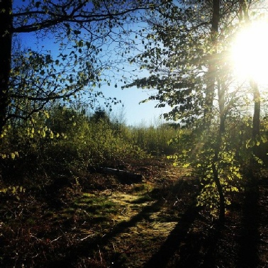
Photograph: The summit of Thynghowe © Mercian Archaeological Services CIC


At various times the project work has received funding from the following:
Birklands Forest Stone on the summit of Thynghowe. ©Lynda Mallett 2016
Trench 1 was located on the southern side of the circular enclosure where it coincided with the boundary of Budby and Edwinstowe. The ditch and bank of the enclosure were present in the trench, but there was no evidence of a bank or ditch associated with the parish boundary at this location. The bank and ditch were subject to environmental sampling. This was undertaken by Allen Environmental Archaeology and (for the project as a whole) has included; geoarchaeology and environmental land use analysis, soil micromorphology analysis, soil thin section analysis, and pollen analysis. The environmental sampling has been combined with that taken from the 2013 excavations and the results were imminent at the time of writing.
Finds from Trench 1 included the proximal fragment of a soft hammer struck blade-
Other finds from the trench included an abraded fragment of pottery, being the foot ring from an unglazed wheel thrown vessel likely of Roman date. Later finds from upper layers of the excavation included parts of a late 19th / early 20th century beverage bottle marked "William Hornby" "Mansfield" with the 'Eclipse' trademark and quantities of spent 7.62mm shell casings. These were date stamped from the 1950s to 1961, demonstrating the continued use of Sherwood Forest for live fire exercises by the military even after the end of WWII.
Trench 2 was located at the western side of the circular enclosure where it coincided with the Budby/Warsop boundary. Excavation showed the ditch of the circular enclosure to be cut by the later ditch of the parish boundary.
Trench 3 was located over an area where a large density of pot boiler stones were evident on the surface of the ground. This area coincided with an area high magnetic responses in the geophysical data. A trench was opened at this location to investigate this feature. Trench 3 revealed a layer of pot boiler stones up to c.0.3m thick. They appeared to have been deposited in this location over a(n unknown) period of time; test pits 8m and 10m south (upslope) found no trace of pot boilers and demonstrated that they had not been washed downhill. The only artefacts found in this deposit were a possible quartzite core and two small fragments of gritstone quern, the latter probably originating in the Derbyshire Peak District.
Due to the lack of clear dating evidence from Trench 3, SUERC have been contracted to undertake thermoluminescence dating on a sample of the pot boilers to attempt to date their last heating.
Magnetometer Survey 2015 & 2016 (report 2017), summary:
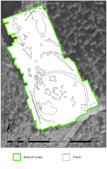
A geophysical magnetometer survey of the enclosure and surroundings adjacent to Hanger Hill known historically as Thynghowe was carried out for the Friends of Thynghowe and the Forestry Commission by Mercian Archaeological Services CIC (Mercian), in 2015 and 2016. The project detected anomalies and trends that represent archaeological remains preserved at the site. This geophysical magnetometer survey alongside the results of excavations by Mercian Archaeological Services CIC (Gaunt & Crossley 2014; Gaunt & Budge 2016; Gaunt, Crossley & Budge 2017 forthcoming), topographic survey (Gaunt 2011), LiDAR Survey (2012) and historic mapping has discovered a large number of archaeological features now confirmed at the site. These include: a ‘thing mound’, Warsop and Edwinstowe boundary stones, the ‘birklands forest stone’, the Warsop and Budby parish boundary ditch and bank, a 75.0 metre -
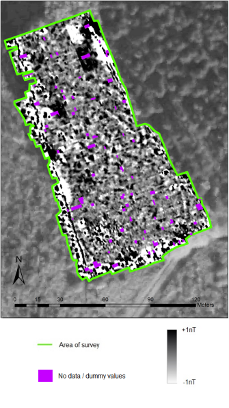
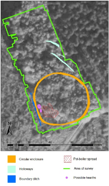
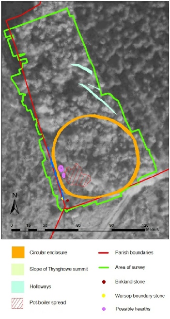
Picture: From Gaunt 2017: Archaeological features detected in magnetometer survey. © Mercian Archaeological Services CIC. Contains OS data © Crown copyright [and database right] 2017. Contains Image © Google Earth. Image © 2017 Getmapping plc.
Picture: From Gaunt 2017: The Thynghowe monument complex. © Mercian Archaeological Services CIC . Contains OS data © Crown copyright [and database right] 2017. Contains Image © Google Earth. Image © 2017 Getmapping plc.
Picture: From Gaunt 2017: Trends in the geophysical data set. © Mercian Archaeological Services CIC . Contains OS data © Crown copyright [and database right] 2017. Contains Image © Google Earth. Image © 2017 Getmapping plc.
Picture: From Gaunt 2017: Magnetometer survey results +/-
Geophysical Magnetometer Survey at Thynghowe, Hanger Hill, in Sherwood Forest.
Andy Gaunt
http://www.mercian-
2013 Excavation by Mercian Archaeological Services CIC, summary.
The excavation took place over 3 days from the 23rd -
The work involved the hand excavation of one 10m x 1.5m trench at right angles to the central section of a curvilinear earthwork consisting of a bank and ditch and an adjacent trackway.
The excavation was undertaken to investigate the nature of the earthwork; to understand its original shape and dimensions and to determine, if possible, the date of its construction and use. Also to determine, if possible, the age of the adjacent trackway.
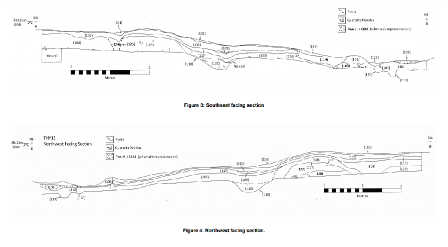
The excavations revealed that the bank and ditch were considerably larger than the visible surface remains suggested. Evidence from the excavation and the preceding topographic survey, LiDAR and historic mapping suggests the feature may have originally formed part of a circular enclosure with the bank on the inside of the ditch.
Environmental evidence does not directly suggest the enclosure was formed to enclose and area of woodland (Mike Allen, pers comm.). If the earthwork was originally circular the internal bank suggests the site was designed to limit access to an internal space.
This function, the location of the feature at the extreme periphery of the Parish of Budby where the parish adjoins two others (often ancient meeting sites are at the periphery of landscapes) (Mallett et al 2012), and the spatial proximity to Hangar Hill (a posited Viking assembly site) suggests that it is not impossible that the enclosure may be associated with the possible Viking meeting site of Thynghowe.
The only artefacts recovered from the excavation (except for CBM, iron and pottery all from the adjacent modern trackway) were Heat Shattered Pebbles. These seem to have been deposited after the ditch and bank were constructed.
Their presence, combined with the environmental evidence, indicates that a Bronze Age or Early Medieval construction period for the bank and ditch is not impossible and may even be most likely.
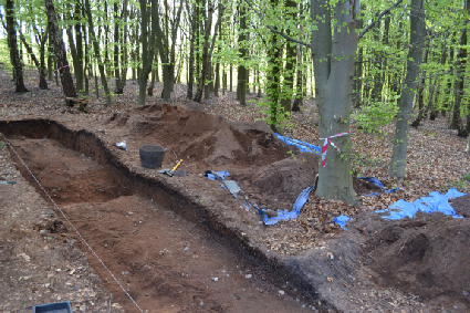
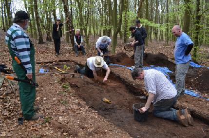
Picture:Volunteers excavating at thynghowe. ©Mercian Archaeological Services CIC 2017
Picture:”Court Circle” excavations 2013. ©Mercian Archaeological Services CIC 2017
The ‘CourtCircle’ Excavation at Thynghowe, Hanger Hill, Sherwood Forest, Nottinghamshire. Archaeological Report. Gaunt and Crossley 2014.
Andy Gaunt and Sean Crossley
http://www.mercian-
Picture: Gaunt & Crossley 2014: Section drawings of the circular enclosure. ©Mercian Archaeological Services CIC 2017
* Download the Archaeological Report for FREE below*
* Download the Archaeological Report for FREE below*

LiDAR data results 2012, courtesy of Friends of Thynghowe/ Geomatics Group Environment Agency. The shaded relief model show high ground in red and low ground in blue.
LiDAR survey 2010 -
Picture: A view of the 2016 excavation towards the summit of Thynghowe ©Lynda Mallett 2016
Picture:Archaeological volunteers at the 2016 excavation ©Lynda Mallett 2016
Picture:Archaeological volunteers at the 2016 excavation ©Lynda Mallett 2016
Picture:Archaeological volunteers at the 2016 excavation ©Lynda Mallett 2016
Picture:Archaeological volunteers at the 2016 excavation. ©Lynda Mallett 2016
Picture:Archaeological volunteers at the 2016 excavation. ©Lynda Mallett 2016
Ground -
Record of Features Investigated by The Friends of Thynghowe:
http://www.thynghowe.org.uk/ResBirk.html
Map of Features Investigated by The Friends of Thynghowe:
A topographic earthwork survey of Thynghowe. Hanger Hill, Nottinghamshire. 2011.
Andy Gaunt, Nottinghamshire County Council. (This is an external link to the Nottinghamshire County Council Website):
http://www.nottinghamshire.gov.uk/media/110119/a-
Photograph: Stuart Brookes of University College London on top of Thynghowe with a Magnetometer 2012.
©Lynda Mallett 2012
Magnetometer Survey -
Topographic Survey -
Revealing the Landscape: Community archaeology in Viking Sherwood Forest
A public lecture presented by Lynda Mallett & Stuart Reddish
on February 28, 2017 at St Mary's University, Nova Scotia
for the Nova Scotia Archaeological Society



Transactions of the Thoroton Society (of Nottinghamshire):
Community Archaeology at Thynghowe, Birklands, Sherwood Forest.
Lynda Mallett, Stuart reddish, John Baker, Stuart Brookes and Andy Gaunt. 2012.
http://www.thorotonsociety.org.uk/publications/tts/trans116.htm

According to Ancient Custom: Research on the possible origins & purpose of Thynghowe
Paper presented at the National Museum of Iceland, Reykjavik, in collaboration with Thingvellir National Park March 9, 2012
Stuart C. Reddish and Lynda Mallett.
2012
issuu.com/piro.co.uk/docs/according_to_ancient_custom_-
Reddish, S. 2010. Paper presented: Viking Law Thing Discovery in Robin Hood's Sherwood Forest, Thynghowe. Program Partner Meeting. Faeroe Islands 05th-
Reddish, S. 2010. Paper presented: Thynghowe: A thing site in the Sherwood Forest, The THING Project. THING Sites International Networking Group 2009 – 2012 Shetland/Orkney Partner Meeting 14-
Reddish, S. & Mallett, L. 2016. Canute: The Danelaw and the Vikings of Sherwood. Published by Public Information Research Organisation:
https://www.researchgate.net/publication/299478639_Canute_Danelaw_and_the_Vikings_of_Sherwood
Friends of Thynghowe Publications about the site -
http://www.thynghowe.org.uk/Publications.html
Thynghowe and Birklands
Stories from the past of Sherwood Forest retold along the route of two perambulations of an ancient boundary
2013
Publications with references to Thynghowe:
Things in the Viking World
Olwyn Owen (ed.)
The Thing Project
Shetland Heritage Publications
2012
The Woodland Heritage Manual
Ian D Rotherham, Melvyn Jones, Lindy Smith, Christinr Handley (eds.)
The Woodland Heritage Champions Project
Wildtrack Publishing
2007
Warsop 1816 to 2016
Steve Horne
Warsop Footpaths & Countryside Group
2016
Academic Publication:
Photograph: Vikings return to the summit of Thynghowe in 2016. ©Lynda Mallett 2016
The Friends of Thynghowe:
http://www.thynghowe.org.uk/index.html
The THING Project -
Friends of Thynghowe Facebook page:
https://www.facebook.com/Thynghowe
2016 Excavations of the Viking Assembly Site at Thynghowe
(The Archaeological Excavation 2016 report will be available to download shortly)
In April 2016 Mercian Archaeological Services CIC undertook a community excavation for the Friends of Thynghowe as part of their Heritage Lottery Funded project: The Vikings of Sherwood: Investigating the Assembly Site of Thynghowe 2015-
Three trenches and two 1m x 1m test pits were excavated at positions designed to answer key questions about the site, and the relationships of the features mentioned above. This was done as part of a community excavation undertaken by volunteers under the supervision of Mercian staff. 53 volunteers dug over the course of 6 days of excavation amounting to 115 person days. This formed a part of the wider public engagement that took place throughout the project.
Project page links:
-
-
-
-
-
-
-
-
The Sherwood Forest
National Nature Reserve Archaeology Survey
-
Long term Research at
King John’s Palace:
Ancient Royal Heart of Sherwood Forest
-
The Sherwood Forest Archaeology Training Fieldschool
-
“Scirwuda-
Ghost and Shadow woods of Sherwood Forest Project
-
Investigating Thynghowe Viking
Meeting Site
-
Searching for the
The Battle of Hatfield
-
-
Fieldswork at St Edwin’s Chapel
-
St Mary’s Norton-
-
Mapping Medieval Sherwood Forest
-
The Sherwood Forest LiDAR
Project
-
Warsop Old Hall
Archaeological Project
-
The Sherwood Villages Project:
Settlement Development in the Forest
-
-
-
Researching Edward IIs fortification at Clipstone Peel
-
-
-
-
The Cistercians of Rufford Project:
Settlement Development, Dynamics and Desertion.
-
Sherwood Forest Environmental Survey
-
World War II in Sherwood Forest -
-
World War I in Sherwood Forest -
-
About Medieval Sherwood Forest
-
Robin Hood and Sherwood Forest
-
-
-
-
-
-
-
-
-
-
-
-
Community Archaeology in Derbyshire
Community Archaeology in Leicestershire
Community Archaeology Nottinghamshire, Excavation, Research, Volunteering, Community Archaeology Derbyshire, Training, Social, Learning, Community Archaeology Leicestershire, Heritage, Involvement, Belonging, Knowledge sharing, Community Archaeology Lincolnshire, Topographic Survey, Talks and Presentations, Outreach, Archaeology Projects , Open Days, Schools, Finds Processing, Day Schools, Field Schools, Young People, Archaeology and History of Sherwood Forest, Pottery Research, Medieval, Roman, Prehistoric, Community Interest Company, Community Archaeology Nottinghamshire.
Community Archaeology in Nottinghamshire
Community Archaeology East Midlands
Community Archaeology in Lincolnshire
Community Archaeology in Yorkshire
Mercian Archaeological Services CIC
Specialists in Community Archaeology, Public Involvement, Research & Training
© Mercian Archaeological Services CIC 2024. Registered Business No. 08347842. All Rights Reserved.


The Future of Sherwood’s Past


Community Archaeology Nottinghamshire, Community Archaeology Derbyshire, Community Archaeology Leicestershire, Community Archaeology East Midlands, Mercian Archaeological Services Community Archaeology for Nottinghamshire, Derbyshire, Sherwood Forest, Leicestershire and the East Midlands. Community Archaeology Nottinghamshire, Community Archaeology East Midlands, Community Archaeology Leicestershire. Archaeological
Thynghowe Viking Assembly Site in Sherwood Forest
