


Community Archaeology Nottinghamshire, Community Archaeology Derbyshire, Community Archaeology Leicestershire, Community Archaeology East Midlands, Mercian Archaeological Services Community Archaeology for Nottinghamshire, Derbyshire, Sherwood Forest, Leicestershire and the East Midlands. Community Archaeology Nottinghamshire, Community Archaeology East Midlands, Community Archaeology Leicestershire. Archaeological

A journey through Sherwood Forest: Newstead Priory to King John's Palace
Award Winners 2016
for "Engaging people in the heritage, history & archaeology of Sherwood Forest".


Some funders and partners:
World-


The following is a “Story from the Forest” which aims to bring history to life. The story is a description of a journey from Newstead Priory to The King’s Houses at Clipstone, in medieval times, and traces the likely route a traveller route through the world famous Sherwood Forest, a traveller would have taken, and gives an idea of what they might have seen along the way.
The story is based on a landscape recreated by historic mapping and document research, LiDAR analysis and much more undertaken by Andy Gaunt and Mercian.
The landscape has been built as part of Mercian’s ‘Mapping Sherwood Forest Project’, which is part of the Sherwood Forest Archaeology Project, and is based on years of research into the landscape of Sherwood Forest.
The landscape of Clipstone described below was researched by Andy Gaunt in the years up to 2011, resulting in his interpretation of the landscape as a designed medieval landscape. The 3D reconstruction of the landscape and palace included here was produced as part of this research. Although he and Mercian have since undertaken a vast amount of research at the site, the 3D reconstruction is included here to give the reader a visualisation of the scale and impressiveness of the site.
Work is currently underway to create a new up-
The aim of the Sherwood Forest Archaeology Project overall is not simply to investigate and to recreate past landscapes, but also to bring them to life through story-
We hope you enjoy the journey…
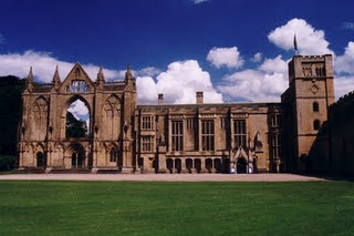
Picture: Newstead Abbey, Sherwood Forest, Nottinghamshire.
Newstead Priory (modern day Newstead Abbey) is situated 10 miles to the north of Nottingham.
In the Medieval Period it was on the western side of the 'High Forest' area of Sherwood, halfway along the western highway from Nottingham in the south to the Royal Manor of Mansfield to the north and was a favoured stop over for travellers.
Most travellers staying at Newstead priory and taking advantage of the hospitality of the Augustinian Canons of Sherwood, who lived there, would have been travelling north or south along the western highway.
However many people in the area would have been undertaking a journey as part of their everyday business in the forest.
The following describes a journey through the medieval landscape of Sherwood Forest, from Newstead Priory to the Kings royal hunting palace at Clipstone 7 1/2 miles to the north east as the crow flies.
Leaving the confines of the priory the traveller would head up the western highway of the forest, still in the grounds of Newstead heading north. To the left the 'Swynisti (pig road) dale' (a reference to the importance of pigs in the Forest landscape) rose to the east running up that way from the valley of the Leen where the priory nestled.
Keeping 'Swynisti dale' to the left hand side the traveller would head further north into the 'Dedde Quene Dale' and head up through the wood that clung to is sides-
The well informed traveller would be aware that this lordship was under the ownership of the Archbishop of York, and had been since Domesday. It would be well not to get caught breaking the Forest law here as the penalty could include Excommunication on top of all the other forms of punishment that could be on the menu.
The road to Blidworth climbed up onto a higher ridge of land and followed the route of the current Ricket lane. It might have been possible to see the herds of the village grazing on the oak-
After a further mile across the heath of Blidworth the arable fields of the village were crossed by the track way. In the valley to the south lay the 'Blyworth fyspole' (the fish pond of the village) at the source of the Doverbeck River which was a boundary of Sherwood Forest further to the south east.
In the valley to the north was Rainworth Water with a moated enclosure-
Men would have dotted the great arable fields tilling the land, and the church of St Mary of the Purification would be visible in the distance.
Having passed through Blidworth the road to Clipstone ran north west towards Oxweydale the (Ox way), before striking north into Blidworth Wode. This large wood stretched for miles to the east and merged with 'Hay Wode' (modern day Haywood Oaks), 'Balkhaw', 'Syre Birkes', 'Lerche haw', 'ye Byschopes Wode' and the 'Burne Abotote wood' (the Brown Abbots Wood-
The road crossed the 'Reinwarth Forthe' (modern day Rainworth (forthe-
It then travelled further north skirting the sides of the hill of 'Kynggus (King's) Ymmislow' and again entering woodland. Here the wood belonged to the crown and was known as 'Nomannes Wode' (the wood belonging to no man). This wood merged into another large area of woodland which included 'Wodhous Wode' (Mansfield Woodhouse Wood).
The track way passed the head of a valley known as 'Falous dale', before crossing the ‘Warmebrook’ know today as ‘Vicar Water’ river at 'ye Blake Forthe (ford)'.
The road then ran alongside the southern edge of the great Park of Clipstone-
The traveller would not fail to be impressed by this status symbol of the Crown and would have been well aware that entry was not a wise option. The road then headed down the valley into Fliskerhaw wood, and out onto the open grass-
The areas were open grazing land for the deer, and provided views to and from the palace as part of the designed romance landscape developed by the crown around their hunting palace.
It would be at this moment that the magnificent Royal Hunting Palace of Clipstone loomed into view. Beautiful, dazzling white in the sun, and set gracefully on a spur of land between the valleys of the River Maun and Vicar Water. This Palace was impressive and dominated the landscape.
Picture: Reconstruction of the designed royal hunting landscape of king John’s palace, kings Clipstone in Sherwood Forest by Gaunt 2011.
The King's Houses at Clipstone-
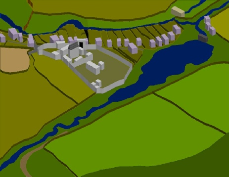
Picture: Reconstruction of King John’s Palace designed royal hunting landscape, Kings Clipstone in Sherwood Forest after by Gaunt 2011.
It should have been possible for a traveller to find accommodation in the village (provided the King wasn't in town with his retinue).
An important visitor might find accommodation in one of the many halls and dormitories within the royal complex, and enjoy hunting at the king's pleasure in his park.
But for all travellers, of high and low status, the arrival in this sylvan retreat would have been greatly welcomed, as the forest had been safely navigated for another day.
(Andy Gaunt first published 13/01/2012 -
Click here for more ‘Stories from the Forest’…
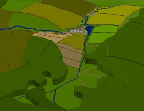
Why not click on the two maps below the top map focuses on the area around Newsetad Abbey. The bottom map focuses on the area around King John’s Palace in King’s Clipstone. Clipstone lies to the north-
Newstead:
Clipstone:
The Future of Sherwood’s Past
Project page links:
-
-
-
-
-
-
-
-
The Sherwood Forest
National Nature Reserve Archaeology Survey
-
Long term Research at
King John’s Palace:
Ancient Royal Heart of Sherwood Forest
-
The Sherwood Forest Archaeology Training Fieldschool
-
“Scirwuda-
Ghost and Shadow woods of Sherwood Forest Project
-
Investigating Thynghowe Viking
Meeting Site
-
Searching for the
The Battle of Hatfield
-
-
Fieldswork at St Edwin’s Chapel
-
St Mary’s Norton-
-
Mapping Medieval Sherwood Forest
-
The Sherwood Forest LiDAR
Project
-
Warsop Old Hall
Archaeological Project
-
The Sherwood Villages Project:
Settlement Development in the Forest
-
-
-
Researching Edward IIs fortification at Clipstone Peel
-
-
-
-
The Cistercians of Rufford Project:
Settlement Development, Dynamics and Desertion.
-
Sherwood Forest Environmental Survey
-
World War II in Sherwood Forest -
-
World War I in Sherwood Forest -
-
About Medieval Sherwood Forest
-
Robin Hood and Sherwood Forest
-
-
-
-
-
-
-
-
-
-
-
-
Mercian Archaeological Services CIC (Community Interest Company)
An Independent Research Company, specialising in Training, Community Archaeology & Public Involvement.
Community Archaeology Nottinghamshire, Excavation, Research, Volunteering, Community Archaeology Derbyshire, Training, Social, Learning, Community Archaeology Leicestershire, Heritage, Involvement, Belonging, Knowledge sharing, Community Archaeology Lincolnshire, Topographic Survey, Talks and Presentations, Outreach, Archaeology Projects , Open Days, Schools, Finds Processing, Day Schools, Field Schools, Young People, Archaeology and History of Sherwood Forest, Pottery Research, Medieval, Roman, Prehistoric, Community Interest Company, Community Archaeology Nottinghamshire.
Community Archaeology in Nottinghamshire
Community Archaeology in Derbyshire
Community Archaeology in Leicestershire
Community Archaeology East Midlands
Community Archaeology in Lincolnshire
© Mercian Archaeological Services CIC 2019. Registered Business No. 08347842. All Rights Reserved.
Community Archaeology in Yorkshire
Project page links:
-
-
-
-
-
-
-
-
The Sherwood Forest
National Nature Reserve Archaeology Survey
-
Long term Research at
King John’s Palace:
Ancient Royal Heart of Sherwood Forest
-
The Sherwood Forest Archaeology Training Fieldschool
-
“Scirwuda-
Ghost and Shadow woods of Sherwood Forest Project
-
Investigating Thynghowe Viking
Meeting Site
-
Searching for the
The Battle of Hatfield
-
-
Fieldswork at St Edwin’s Chapel
-
St Mary’s Norton-
-
Mapping Medieval Sherwood Forest
-
The Sherwood Forest LiDAR
Project
-
Warsop Old Hall
Archaeological Project
-
The Sherwood Villages Project:
Settlement Development in the Forest
-
-
-
Researching Edward IIs fortification at Clipstone Peel
-
-
-
-
The Cistercians of Rufford Project:
Settlement Development, Dynamics and Desertion.
-
Sherwood Forest Environmental Survey
-
World War II in Sherwood Forest -
-
World War I in Sherwood Forest -
-
About Medieval Sherwood Forest
-
Robin Hood and Sherwood Forest
-
-
-
-
-
-
-
-
-
-
-
-